
Super Sunday Adventure
adventureleisureNZNZ Placestravelwalks
Pukekōhatu via Pylon Track

It was a stunning blue sky Spring day and the need to get up high and look down on the world was strong in me! So, I persuaded my running buddy Jo to go on an adventure. Gnarly, technical, non-runnable tracks are not really her jam but I took the gamble that there was enough runnable down on the return route to keep her happy!! It was a new route for us and it turned out to be the perfect day for it so I thought I’d share it.
Note: The Pylon Track is not marked on the Information Board in the car park nor is it on NZ Topo map. It is described on the DoC site. It was built to replace the Kauri Loop Tracks which have been closed to protect the Kauri.
From the Wairongomai car park take the Low Level Loop Track. About 200 metres in there is a signpost directing you down to the right to the Pylon Track. Very quickly you arrive at the river. It is easy enough to boulder hop and keep your dry feet on a good day but after heavy rain, it may be impassable as it’s quite wide.


The path continues up through the forest on the other side. You climb steadily and at times steeply through varied vegetation. Tall Rata trees are a feature of the forest and we were chatting to a DoC worker who goes up to monitor them. He was also part of the team that constructed the Pylon Track in 2015. The path is reasonably obvious and well-marked but keep an eye out for the orange markers as it isn’t a well-walked path and fallen leaves had formed a thick blanket. There were also a few fallen trees that provided interesting diversions and obstacles!

All part of the adventure. As you climb there are a few ‘vegetation windows’ that give you views of the Waikato Plain and Te Aroha. The path follows a ridgeline and the last 200m of climbing is quite steep. According to our friendly DoC guy it was one of the steepest pack pony routes. There are still a few remains of the steel power pylons which were used for the power line linking the Horahora hydro-electric power station with the Waihi gold mine and Victoria Battery in the Karangahake Gorge.
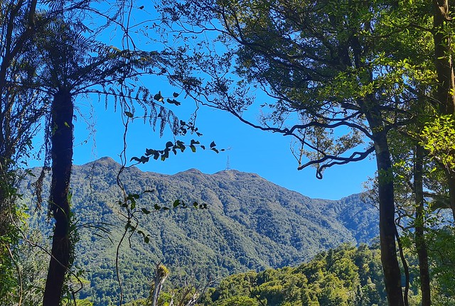


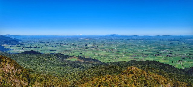
At about 4km in (and roughly 600m ascent), you reach the bushline and emerge into the open to an amazing view of the Waikato in front, the Kaimais stretching out to your left and Te Aroha to your right. The climb is definitely worth it! It was such a clear day that we could see the snowy peaks of Ruapehu and Ngarauhoe in the distance. It is quite exposed so probably not a great trail to do on a cold, windy day. We quickly cooled down in the breeze – the sun was warm but the air temperature with additional wind chill factor was bitter.


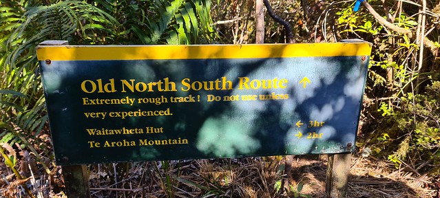
Continue to climb for a few more metres over more scrambly terrain to a rocky outcrop. This is apparently known as Pylon Peak. On the map there is a summit called Pahiko marked off to the right as you climb. There is an old sign and a path leading off to the right which is not marked on the map which I suspect takes you to the Pahiko summit but this description suggests there are no views from it. We carried on to the left heading towards Te Aroha. This is the Old North-South Route and it is pretty slow going to the junction. You do need to keep an eye on the markers but the path is mostly obvious just not very well-used so quite overgrown.
You are following the contours now on the ridge so apart from a few undulations it is pretty flat. There were a few muddy patches to negotiate which could be challenging after heavy or prolonged rain. At this point I started to lose a little bit of confidence in my map reading skills and route planning – surely we should have got to the junction by now? We stooped to check the map – I had the NZTopo paper map and also brought it up on my phone so I could zoom in. I reckoned we had a little bit further to go but not far so we continued on. After about 5 minutes we rounded a corner and I spotted the green DoC sign up ahead. Phew!

It was roughly 2kms to that T-Junction and then we headed left towards Te Aroha mountain. The track is now much more runnable; there have been a couple of landslips which have been cleared which provide a clear view down to the valley. Pukekōhatu was my goal summit at 799m is to the right off the track as you run but sadly there didn’t seem to be a path leading to it and after spending longer than expected in the gnarly stuff we were keen to get running.

We were running along the ridge still and there were some cool views between the trees. It didn’t take long to get down to Wairongomai Saddle junction running along more formed trails. For a longer walk you could turn right and climb the track Te Aroha but then you either come back the way you came or head down to Te Aroha domain and then another 7km or so along the road back to the carpark.


We went left to go down the tracks back to Wairongomai Road. This is the main Wairongomai Valley and you will start to see signs of the old rail tracks that are part of the network that fed the goldmines in the 1800s. A phone torch is sufficient to light the way through a short tunnel and then you can pick whichever route you like to get back to the car park.

We went down the side of the May Queen Incline, past the top of Butler’s Incline onto the High Level Pack Track and then on the Cadman Track and straight down to the car park. If you haven’t been this way before there are plenty of remnants of the goldmines and the tramways built to carry the gold to explore and wonder at.

It took us around 3 and a half hours to the do the 15km circuit but we didn’t really stop except for photos and a bit of route finding as described above and we did run the 8kms from Pukekohatu summit down to the car park. The sign at the start of the Pylon track suggests 4 and a half hours to get to the North South Track junction and our friendly DoC guy was pretty surprised that we did the whole circuit in less than 4 hours. He reckons most people would take the 4 hours to get to the top and take a full day to do the full circuit. Having said that we’re pretty swift for a couple of ‘old nannies’!

Leave a comment